
18/09/2018
Guidelines
1. Grid Areas
- The offshore area shall be divided into grid areas.
- Grid areas shall be bounded on the east and west sides by successive meridians of longitude of the series 50 degrees 00' 00", 50 degrees15' 00", 50 degrees 30' 00", which series may be extended as required.
- Grid areas shall be bounded on the north and south sides by straight lines joining the points of intersection of the east and west boundaries with successive parallels of latitude of the series 40 degrees 00' 00", 40 degrees 10' 00", 40 degrees 20' 00", which series may be extended as required.
- A grid area shall be referred to by the latitude and longitude of its northeast corner.
- The boundary between the north and south halves of a grid area is the north boundary of sections 5, 15, 25, 35, 45, 55, 65, 75, 85, and 95.
- The boundary between the east and west halves of a grid area is the west boundary of sections 41 to 50.
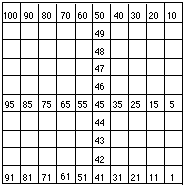
2. Sections
- Every grid area shall be divided into 100 sections.
- Sections shall be bounded on the east and west sides by meridians spaced at intervals of one-tenth of the interval between the east and west boundaries of the grid area.
- Sections shall be bounded on the north and south sides by straight lines drawn parallel to the north and south boundaries of the grid area and spaced at intervals of one-tenth of the interval between the north and south boundaries of the grid area.
- A section shall be identified by the number to which it corresponds in the following diagram:
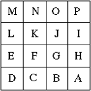
3. Units
- Every section shall be divided into 16 units.
- Units shall be bounded on the east and west sides by meridians spaced at intervals of one-quarter of the interval between the east and west boundaries of the section.
- Units shall be bounded on the north and south sides by straight lines drawn parallel to the north and south boundaries of the section and spaced at intervals of one-quarter of the interval between the north and south boundaries of the section.
- A unit shall be identified by the letter to which it corresponds in the following diagram:
4. Target Areas
- A target area is an area 200 metres square lying within a unit and oriented due north-south and east-west and situated symmetrically about the intersection of a line joining the midpoints of the east and west boundaries of the unit with a line joining the midpoints of the north and south boundaries of the unit.
- A target area shall be referred to by the letter of the unit in which the target area is located.
5. Datum
- All latitudes and longitudes used in this Guideline shall be determined according to the North American Datum of 1927.
| Document Title |
|---|
|
|